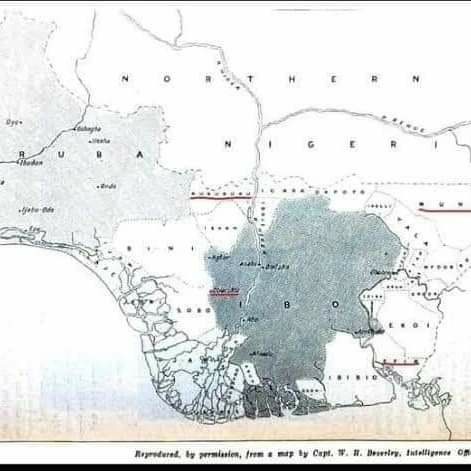
This is 1856 -1911 Map by British Researchers. A further prove that Igboland Is Not Southeast alone.
This is 1856 -1911 Map by British Researchers. A further prove that Igboland Is Not Southeast alone.
As far back as 1856 before Nigeria came into being a nation, the geographical location of Igboland have already been defined and well harmonized as a people of same mutual intelligible language, culture, food and traditions.
Below is the official map, coordinates of Igbo territory
This geographic points have been specified for over 120 years even before the balkanization of the Igbo Nation following the advent of the civil war which caused its fragmentation in 1967.
Until date Non of the Igbo tribes who live within this territory ever contested it, So when I tell you that Igbo land spans through BONNY, OPOBO, BILE, KALABARI and OKIRIKA, I haven’t told you lie neither have ASARI DOKUBO told any lies in his affirmation.
Imagine tribes described as “petty” in this document now wants to annexed a nation of ancient people in their own domain?
igbosmustunite