Why Biafra Is Not a Landlocked Nation (Geographical Perspective)
Why Biafra Is Not a Landlocked Nation (Geographical Perspective)
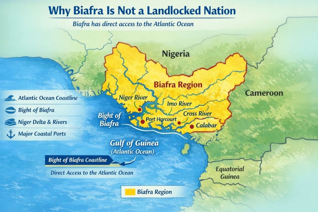
The claim that Biafra would be a landlocked nation is not supported by geography. A careful examination of historical and physical geography shows that Biafra has direct access to the Atlantic Ocean through its southern coastline along the Gulf of Guinea.
- Biafra Has a Coastline on the Atlantic Ocean
Geographically, the territory historically known as Biafra lies along the Gulf of Guinea, part of the South Atlantic Ocean. During the existence of the Republic of Biafra (1967–1970), the country had a southern coastline that opened directly into the Atlantic. Gulf of Guinea
Historical geographic records confirm that Biafra’s southern boundary was the Atlantic coast. The territory bordered Nigeria to the north and west, Cameroon to the east, and the ocean to the south.
Wikipedia
Because it had a coastline touching the Atlantic Ocean, by definition it cannot be considered landlocked. - The Bight of Biafra Defines Its Maritime Geography
One of the strongest geographical proofs lies in the Bight of Biafra, a large bay on the Atlantic coast of West Africa. Bight of Biafra
This bay forms part of the Gulf of Guinea and stretches roughly 600 km along the West African coast, bordered by southeastern Nigeria, Cameroon, Equatorial Guinea, and Gabon.
Encyclopedia Britannica
Important coastal cities and ports around this bay include Port Harcourt and Calabar in Nigeria and Douala in Cameroon. These ports historically connected inland regions of the Biafran territory to global maritime trade routes.
Encyclopedia Britannica
The very name “Biafra” itself historically comes from this coastal geographic feature, further emphasizing the maritime identity of the region. - Major Rivers Connect the Interior to the Ocean
Biafra’s geography also includes several major rivers that flow directly into the Atlantic through the Bight of Biafra. These rivers create natural waterways linking inland regions to the sea. Examples include:
Niger River
Cross River
Imo River
These rivers drain into the Gulf of Guinea, forming extensive delta systems and estuaries.
River networks like these historically supported navigation, fishing, and maritime trade, linking inland communities with the Atlantic coast. - The Niger Delta Provides Extensive Coastal Access
Another important geographical feature is the Niger Delta, one of the largest river deltas in the world. Niger Delta
This region contains numerous creeks, estuaries, and natural channels leading directly to the Atlantic Ocean. These waterways have long supported shipping routes, oil exports, and maritime activities in the region.
Because of this vast coastal system, the southeastern region associated with Biafra has multiple natural outlets to the sea. - Historical Coastal Trade and Ports
For centuries, the Bight of Biafra region was involved in global maritime trade. Ports such as Bonny, Brass, and Old Calabar served as major trading centers from the 16th to the 19th centuries.
Encyclopedia Britannica
This long history of maritime trade demonstrates that the region has always been connected to the Atlantic Ocean.
Conclusion
From a geographical standpoint, Biafra cannot be described as landlocked.
The region:
Possesses a coastline on the Atlantic Ocean.
Lies directly on the Bight of Biafra, part of the Gulf of Guinea.
Contains major rivers that flow into the ocean.
Includes extensive delta and estuary systems providing maritime access.
These geographical features clearly show that Biafra is part of the Atlantic coastal zone of West Africa rather than an inland territory.