THE KAZUNGULA CROSSING — WHERE FOUR NATIONS MEET AT THE EDGE OF THE ZAMBEZI
THE KAZUNGULA CROSSING — WHERE FOUR NATIONS MEET AT THE EDGE OF THE ZAMBEZI
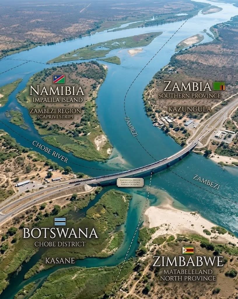
At a remarkable point along the mighty Zambezi River lies one of the most geographically intriguing spaces on the African continent — a narrow convergence of four sovereign states: Botswana, Zambia, Zimbabwe, and Namibia.
This location, known as Kazungula, has long been described as a “quadripoint” — a place where four national borders meet. However, from a strictly legal and cartographic standpoint, the situation is more precise: the borders do not meet at a single shared point, but rather lie in extremely close proximity, separated by short river boundaries. This subtle distinction has historically prevented direct territorial overlap between all four nations at one exact coordinate.
At the centre of this convergence stands the modern Kazungula Bridge — an engineering and diplomatic milestone officially opened in 2021. The bridge connects Botswana and Zambia directly, replacing the older ferry system that once carried goods and people across this strategic corridor.
Its construction was not merely infrastructural — it was geopolitical.
For decades, movement through this region required navigation around complex border arrangements, often involving Zimbabwean territory. The bridge redefined that dynamic, providing Botswana and Zambia with a direct, sovereign-controlled trade and transport route. This has significantly improved regional logistics, trade efficiency, and economic integration within the Southern African Development Community (SADC).
Geographically, the surrounding landscape is shaped by the branching channels of the Zambezi and the nearby Chobe River system. Seasonal water levels, sediment islands, and shifting channels have historically contributed to the complexity of defining precise borders in this region — a reminder that African boundaries, often drawn during colonial negotiations, were imposed upon fluid natural systems that do not conform to rigid lines.
Historically, this region was not divided as it is today. It formed part of a broader cultural and ecological zone inhabited by interconnected communities, including Batswana groups and others whose movement, trade, and kinship networks predated modern state boundaries. The rivers were not barriers — they were lifelines.
Today, Kazungula stands as both a symbol of division and unity:
Division — in the sense of four distinct modern states
Unity — in the continued flow of people, culture, and commerce across them
It is a place where geography, history, and modern statecraft intersect — not in abstraction, but in visible, physical form.
From above, it appears as a simple crossing.
In reality, it is one of the most strategically and historically layered junctions in Africa — where water, land, and sovereignty meet within a few hundred metres of one another